


Do you use topographic maps for hunting?
 05-12-2010 | 07:25 PM
#11
Nontypical Buck
Joined: Feb 2003
Posts: 3,067
Likes: 0
From: Garfield NJ USA

I'm surprised that this day and age that hunters even use topo's, what with the GPS cheat. I still use my 8 digit co-ordinates, I love the challenge, and keeping the skeeeellls sharp! Reminds of the time that I was sending newbies down the commo shop for spools of "contour" line.
Reminds me of the days of sending boots to the radio shack for sound powered phone batteries or to the HT shop for an HT punch, DC Central for bulkhead remover. Telling the boots to report a CGU11 or B1RD to the bridge. Oh those were the days.

 05-16-2010 | 09:11 AM
#13
Spike
Joined: Jan 2010
Posts: 42
Likes: 0
There is no gps cheat. They do not replace a map and compass. A map shows you terrain, water, valleys, funnels, ridgelines...
Five minutes with a map and you know more than two days random wandering- not that you dont need to hoof it. It lets you plan your hoofing. I do use a gps for plotting stand sites, distances, etc. but it is no where near as helpful or versatile as a map and compass...especially once the batteries die, or it doesnt triangulate due to steep terrain or tree cover.
Five minutes with a map and you know more than two days random wandering- not that you dont need to hoof it. It lets you plan your hoofing. I do use a gps for plotting stand sites, distances, etc. but it is no where near as helpful or versatile as a map and compass...especially once the batteries die, or it doesnt triangulate due to steep terrain or tree cover.
A gps does as well. I got free topo's at gpsdepot.com. I save my tracks and make my own map using satillite images with my tracks superimposed.
The land masses around here aren't really so big that a map would be of any use. You can hear traffic enough to orient yourself to that.
A gps can help you with details in an area, where the tracks are, where stands are, ect. Here is an example of what I print out for our use. They are helpful in communicating your position to other hunters.
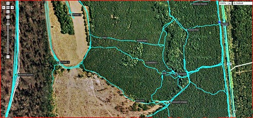
You can't tell but there are waypoints on the map of differant things.
My gps is basically a topo map with real time position and path superimposed. Sometimes it's harder to pan out, that's why we also print maps of some areas.
05-16-2010 | 09:17 AM
#14
Spike
Joined: Jan 2010
Posts: 42
Likes: 0
I guess I will have to explain this. I realize there are some who have very keen and cultured "skills" but it seems something is being overlooked.
A GPS is a great tool, fine indeed. But what a GPS can't do is show you a good, large chunk of land all at once and let you see how the lay of the land actually is and how it works together.
Try to do that with a 3" X 3" screen.
A GPS is a great tool, fine indeed. But what a GPS can't do is show you a good, large chunk of land all at once and let you see how the lay of the land actually is and how it works together.
Try to do that with a 3" X 3" screen.
I see gps's and m&c as working together, not mutually exclusive. I actually always have a small compass with my gps, to check the electronic compass.
Gps'r's have a few quirks, which you can be aware of in preparation, but if you don't practice with it and learn the features and functions, it's just a rock with batteries. I have known folks like that, it's not really the gps's fault you don't know how to use it.
05-16-2010 | 11:19 AM
#15
Typical Buck
Joined: Nov 2006
Posts: 647
Likes: 0
From:
I use them and aerial maps of the area I entend to hunt to figure out what areas are going to be the most inaccessible. More than likely these are are gonna be the places that the big guys will be. These are the places to hunt.
05-16-2010 | 01:27 PM
#16
Fork Horn
Joined: Sep 2009
Posts: 420
Likes: 0
From: Tug Hill NY
A gps does as well. I got free topo's at gpsdepot.com. I save my tracks and make my own map using satillite images with my tracks superimposed.
The land masses around here aren't really so big that a map would be of any use. You can hear traffic enough to orient yourself to that.
A gps can help you with details in an area, where the tracks are, where stands are, ect. Here is an example of what I print out for our use. They are helpful in communicating your position to other hunters.
You can't tell but there are waypoints on the map of differant things.
My gps is basically a topo map with real time position and path superimposed. Sometimes it's harder to pan out, that's why we also print maps of some areas.
The land masses around here aren't really so big that a map would be of any use. You can hear traffic enough to orient yourself to that.
A gps can help you with details in an area, where the tracks are, where stands are, ect. Here is an example of what I print out for our use. They are helpful in communicating your position to other hunters.
You can't tell but there are waypoints on the map of differant things.
My gps is basically a topo map with real time position and path superimposed. Sometimes it's harder to pan out, that's why we also print maps of some areas.
