Originally Posted by
Daveboone
There is no gps cheat. They do not replace a map and compass. A map shows you terrain, water, valleys, funnels, ridgelines...
Five minutes with a map and you know more than two days random wandering- not that you dont need to hoof it. It lets you plan your hoofing. I do use a gps for plotting stand sites, distances, etc. but it is no where near as helpful or versatile as a map and compass...especially once the batteries die, or it doesnt triangulate due to steep terrain or tree cover.
A gps does as well. I got free topo's at gpsdepot.com. I save my tracks and make my own map using satillite images with my tracks superimposed.
The land masses around here aren't really so big that a map would be of any use. You can hear traffic enough to orient yourself to that.
A gps can help you with details in an area, where the tracks are, where stands are, ect. Here is an example of what I print out for our use. They are helpful in communicating your position to other hunters.
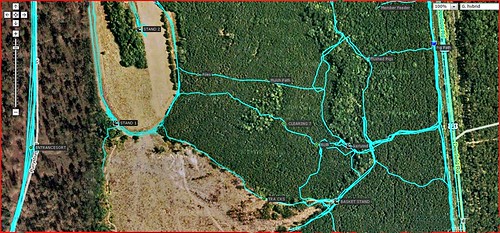
You can't tell but there are waypoints on the map of differant things.
My gps is basically a topo map with real time position and path superimposed. Sometimes it's harder to pan out, that's why we also print maps of some areas.