


Riverbottoms and Drainages
 06-26-2009 | 11:18 AM
#1
Thread Starter
Senior Member
Joined: Nov 2006
Posts: 2,320
Likes: 0
From: Portage WI/Racine WI
I'm looking at a tract of public land that has a lot of river bottom and drainage for the terrain. Very little in terms of fields but from the surrounding area that I am familiar with, I'd assume there is quite a variety browse. How would you go about hunting it?
btw: I'll try getting a few pictures up shortly
Thanks All!
btw: I'll try getting a few pictures up shortly
Thanks All!
 06-26-2009 | 11:54 AM
#2
Thread Starter
Senior Member
Joined: Nov 2006
Posts: 2,320
Likes: 0
From: Portage WI/Racine WI
Ok, so here is an aerial of the area. The large red dot is the parking area (for reference)
The green line is part of a levee that is about 10-12 feet higher than the surrounding bottom, and the red dot on the levee is the best access point to the river bottom. So with that little bit of info as a starting point, what areas jump out at you? What direction are you heading first and what are you looking for?
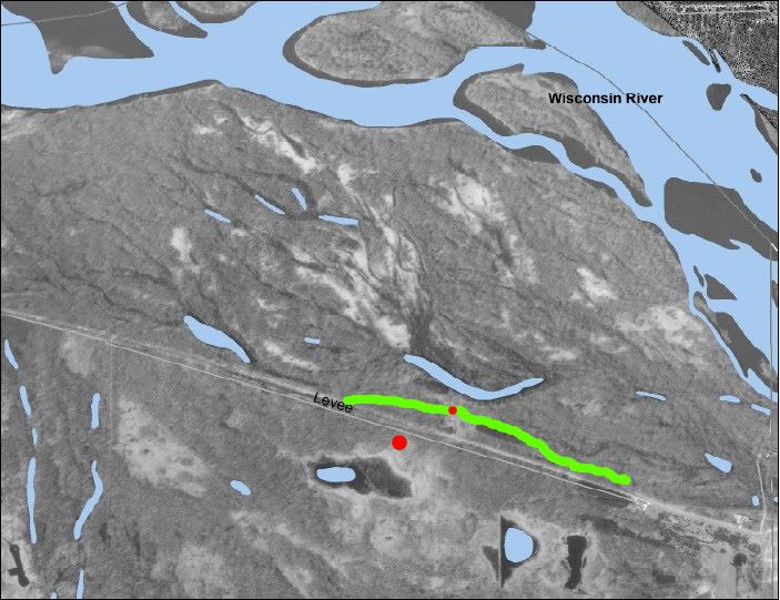
The green line is part of a levee that is about 10-12 feet higher than the surrounding bottom, and the red dot on the levee is the best access point to the river bottom. So with that little bit of info as a starting point, what areas jump out at you? What direction are you heading first and what are you looking for?
06-26-2009 | 01:40 PM
#3
Nontypical Buck
Joined: Feb 2003
Posts: 2,285
Likes: 3
From: west central wi USA
I don't see any cropland nearby, although I suspect it wouldn't be far. I'd look to see ifI had any swamp oaks or oakridges on or near the site and check those out first. I've hunted the WI river bottoms near Portage and they definately will spend some time there if there acorns.
06-26-2009 | 03:08 PM
#4
Nontypical Buck
Joined: Sep 2004
Posts: 3,612
Likes: 0
From: Manassas, VA
Austin, do you have the coordinates to the area? I would like to look at it from a topo view. I always seem to be drawn to water so I would consider looking at those three lakes in the middle.
Have you seen anyone else scouting the area? If so, where are they entering? Again, if you can post the coordintes that would be really helpful. Analyzing stuff like this helps my hunting skills.
One more thing, are you able to hunt those islands out in the river?
Have you seen anyone else scouting the area? If so, where are they entering? Again, if you can post the coordintes that would be really helpful. Analyzing stuff like this helps my hunting skills.
One more thing, are you able to hunt those islands out in the river?
06-26-2009 | 07:10 PM
#5
Thread Starter
Senior Member
Joined: Nov 2006
Posts: 2,320
Likes: 0
From: Portage WI/Racine WI
ORIGINAL: Wingbone
I don't see any cropland nearby, although I suspect it wouldn't be far. I'd look to see ifI had any swamp oaks or oakridges on or near the site and check those out first. I've hunted the WI river bottoms near Portage and they definately will spend some time there if there acorns.
I don't see any cropland nearby, although I suspect it wouldn't be far. I'd look to see ifI had any swamp oaks or oakridges on or near the site and check those out first. I've hunted the WI river bottoms near Portage and they definately will spend some time there if there acorns.
06-26-2009 | 07:10 PM
#6
Thread Starter
Senior Member
Joined: Nov 2006
Posts: 2,320
Likes: 0
From: Portage WI/Racine WI
ORIGINAL: virginiashadow
Austin, do you have the coordinates to the area? I would like to look at it from a topo view. I always seem to be drawn to water so I would consider looking at those three lakes in the middle.
Have you seen anyone else scouting the area? If so, where are they entering? Again, if you can post the coordintes that would be really helpful. Analyzing stuff like this helps my hunting skills.
One more thing, are you able to hunt those islands out in the river?
06-26-2009 | 07:24 PM
#7
Thread Starter
Senior Member
Joined: Nov 2006
Posts: 2,320
Likes: 0
From: Portage WI/Racine WI
So here is the topo...
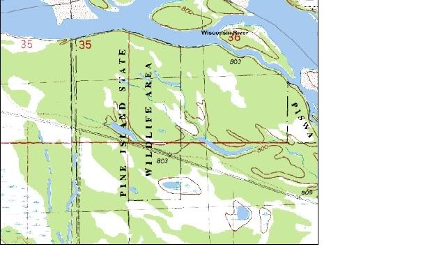
You can see that the area is relatively flat - most of the drainage areas don't even show on the topo because the elevation change is so little.
I do know that most of the bottom is filled with mixed hardwoods with scattered canary grass patches, with the exception of the far western edge of the aerial, which has a bit more pine mixed in with the hardwood and also has less low-lying brush.

