


QuickTip Google maps
 08-27-2009 | 07:25 AM
#1
Thread Starter
Spike
Joined: Mar 2008
Posts: 31
Likes: 0
Just something I used for another reaason a few years ago and soon as bow season came even half way close popped in my head.
The actual web addy is www.maps.google.com
Although its not big budget close up it has terrain, and satelite which is nice. Granted you do have to do you own "homing in" on you hunting area, and not exactly sure how often it gets updated, I like using it to plan scoutting areas.
You can print a map of your area but it doesn't have the option of satelite pic, kinda bums me a bit. But I figured another idea that I like personally. Print off a map of your area, section it off with a pencil/pen and a ruler. Granted you may have to compare to the satelite veiw, or you can drawn in your own area. I tried and wasn't happy, so that I scrapped for now. But anyway after you get your area map, do a little scoutting, hang stands, get some cam pics or whatever your bowl of appetizers. Mark em. Seems simple and whats cheaper than free?
Easy way to get a good referance model. When working with my low budget. More work than other options but probably the best option for someone with very limitted budget. No printer? well best I can offer then is to send a link to your email addy. Quick look if you memory jumper.
Just hopin I can add a little to someones arsenal this year.
 08-27-2009 | 07:35 AM
#2
Thread Starter
Spike
Joined: Mar 2008
Posts: 31
Likes: 0
Just an update. You can print a satelite pic, just send the link to your email. Do NOT use the print option. Highlight the page with satelite photo, use the dile "print preveiw" make sure your getting the photo not a plain map. Then click print. Zip instant, almost, satelite pics. 1 downside you can only zoom in so far with the satelite pic. But can easily pick out my house and other buildings easy enough.
08-27-2009 | 08:00 AM
#3
Typical Buck
Joined: Oct 2005
Posts: 675
Likes: 0
From: South Carolina
You should try Google Earth. It's a free download that is automatically updated with satelite images. You need broadband or high-speed internet access for it to work but you can get some really good maps that way. You can even put little pushpins on the maps where your stands are or mark trails. These are saved to your hard drive while the satelite images remain hosted by Google. That way the pushpins are still there the next time you open the program and when they update the images you get those automatically.
08-27-2009 | 08:43 AM
#4
Typical Buck
Joined: Aug 2009
Posts: 549
Likes: 0
From: NY
You should try Google Earth. It's a free download that is automatically updated with satelite images. You need broadband or high-speed internet access for it to work but you can get some really good maps that way. You can even put little pushpins on the maps where your stands are or mark trails. These are saved to your hard drive while the satelite images remain hosted by Google. That way the pushpins are still there the next time you open the program and when they update the images you get those automatically.
08-27-2009 | 09:38 AM
#5
Nontypical Buck
Joined: Mar 2006
Posts: 1,900
Likes: 0
From: North Central, Iowa
Try Bing Maps, formally MSN Maps. http://www.bing.com/maps/
You can go even more detailed, and the image is bigger, I just made it small to fit it.
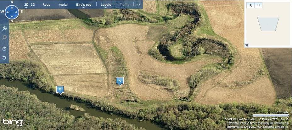
You can go even more detailed, and the image is bigger, I just made it small to fit it.
08-28-2009 | 09:11 AM
#8
Thread Starter
Spike
Joined: Mar 2008
Posts: 31
Likes: 0
Thanks guys. I do like google earth. I didn't see a terrain elevation option on there that googlemaps has. But I don't mind cross referancing 2 sites to get all my info. The homeworks sometimes better than the end grade.
08-28-2009 | 10:35 AM
#9
Nontypical Buck
Joined: Apr 2009
Posts: 1,130
Likes: 0
From: VA
As far as bringing something with you, the USGS site lets you download topo maps free.
Go to http://store.usgs.gov/b2c_usgs/usgs/...a=%24ROOT)/.do
These maps are the "7.5 minute" maps that used to be sold at a lot of hiking shops.
Follow the instructions on the website for downloading them. You open them with adobe reader/acrobat and will be promted to download a safe application that lets you plot lat/long waypoints.
Finally, since a full size 7.5 chart is too big to print, use the "snapshot tool" that is already on adobe reader/acrobat to take a pic of the area you want, then when you print, your printer will automatically size your snapshot to your printer paper.
A cheap way to get an accurate chart of where you plan to go.
