


stand placement from aerial photo
 07-30-2009 | 11:23 AM
#1
Thread Starter
Junior Member
Joined: Jul 2009
Posts: 1
Likes: 0
joined a new club and wanted everyones opinion of starter stand placement for the new club. we hare hunting 87 & 85 tracts of land. let me know what you guys think.
Thanks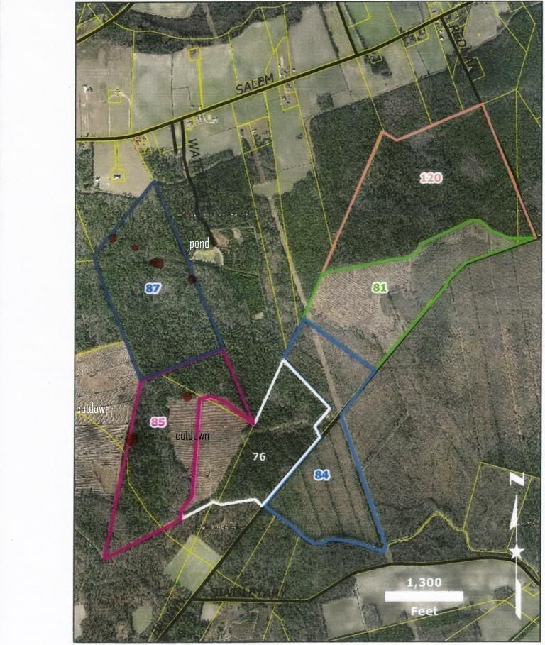
Thanks
 07-30-2009 | 05:38 PM
#3
Boone & Crockett
Joined: Feb 2003
Posts: 10,079
Likes: 0
From: Ponce de Leon Florida USA
Really need a lot more information than just what an aerial can tell. Looks like maybe 75 acres of timber in 87 and maybe 60 acres of timber in 85. Are there any planted agriculture fields contiguous to the tracts, what is "cut down", how do you access the tracts, how thick is the ground cover, how many people hunting the area, main trail locations, do the drainage areas stay wet all the time, etc.
07-30-2009 | 08:54 PM
#5
Giant Nontypical
Joined: Feb 2003
Posts: 6,744
Likes: 1
From: Darien, IL
I think you might be wasting your time. I used a real good magnifying glass and didn't see any deer on that map anywhere.
But if I had to guess one might come along for some reason or another I'd put a stand right in the middle of the woods above the number 85 where the woods funnel.
And the bottom right of 85 where it meets 76 (another funnel).
But if I had to guess one might come along for some reason or another I'd put a stand right in the middle of the woods above the number 85 where the woods funnel.
And the bottom right of 85 where it meets 76 (another funnel).
Last edited by uncle matt; 07-30-2009 at 08:57 PM. Reason: add
08-01-2009 | 06:06 PM
#8
Spike
Joined: Feb 2006
Posts: 14
Likes: 0
From: Michigan
If you want me to look over the maps in detail I'm happy to give you my advice. Most of my hunting buddies think I'm a map geek. Visit me at www.strictlywhitetails.com and drop me an email.
08-01-2009 | 06:11 PM
#9
Nontypical Buck
Joined: Sep 2008
Posts: 2,646
Likes: 0
From: Chippewa county, WI.
With what I can see the funnel in 85 is the most obvious. If that's a field north of 87 I'd check that out, and if it's dry since I don't see any creeks or rivers I would definitely look for sign on the east side of 85 to see if they are heading for the pond.
If those "cutdowns" are sections of logged woods those are always great bedding areas after they grow up thick.
If those "cutdowns" are sections of logged woods those are always great bedding areas after they grow up thick.
