


Stand Placement Suggestions
 04-04-2008 | 02:28 PM
#11
Thread Starter
Typical Buck
Joined: Oct 2005
Posts: 808
Likes: 0
From: Rutland, MA
ORIGINAL: Double Creek
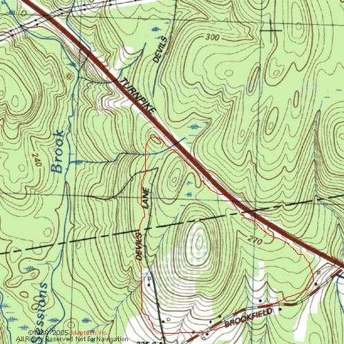
Whats the scale? How many acres are we looking at? Is it mature timber? What is that sport of darker timber north of the field? Is the apple orchard grown over or do the bush hog it? Give us some more details!
Whats the scale? How many acres are we looking at? Is it mature timber? What is that sport of darker timber north of the field? Is the apple orchard grown over or do the bush hog it? Give us some more details!
Race,
You are correct, that dark area North of the orchard are Oaks, they are sitting up on a ledge. I am looking on finding a topo to post.
As for the creek that runs west of the pear orchard. It is usually dried up. When they logged 20years ago, it kinda followed the skidder path.

 04-04-2008 | 03:51 PM
#14
Joined: Jan 2008
Posts: 362
Likes: 0
From:
How could you posibly tell by looking at picture?Sorry I can t imagine how anyone could even say a thing without spending a week walking around any given spot thats just a basic understanding.But maybe some ppl on here are better at looking at charts and maps then me only 30 years navagating a 200 ton fishing vessel all over the east coast but what do i know. Place your stand along rub lines between where they bed and where they feed look for vegation edges ridges bottle necks of cover.
04-04-2008 | 03:52 PM
#15
Nontypical Buck
Joined: Apr 2008
Posts: 1,204
Likes: 0
From: Pingree Grove, IL
In the morning I would hunt the Oaks north of the Orchard and I'd concentrate from the middle to the southernmost part on the western edge.
In the afternoon I would switch to the area of the southeast corner of the apple orchard or the dry creekbed close to where the road crosses on the south west end of the Pear orchard left of the house 150 yards and 75-100 yards from the road.
Other than that I might check out the dry creekbed or logging road. It also looks like there is a field southeast of the orchard, what is that field all about?
04-04-2008 | 04:02 PM
#16
Thread Starter
Typical Buck
Joined: Oct 2005
Posts: 808
Likes: 0
From: Rutland, MA
ORIGINAL: blackfish
How could you posibly tell by looking at picture?Sorry I can t imagine how anyone could even say a thing without spending a week walking around any given spot thats just a basic understanding.But maybe some ppl on here are better at looking at charts and maps then me only 30 years navagating a 200 ton fishing vessel all over the east coast but what do i know. Place your stand along rub lines between where they bed and where they feed look for vegation edges ridges bottle necks of cover.
How could you posibly tell by looking at picture?Sorry I can t imagine how anyone could even say a thing without spending a week walking around any given spot thats just a basic understanding.But maybe some ppl on here are better at looking at charts and maps then me only 30 years navagating a 200 ton fishing vessel all over the east coast but what do i know. Place your stand along rub lines between where they bed and where they feed look for vegation edges ridges bottle necks of cover.
By the way can anyone recommend a good book on how to read topos related to deer hunting?
04-04-2008 | 05:05 PM
#17
Joined: Feb 2004
Posts: 3,982
Likes: 0
From: Inverness, MS
04-04-2008 | 05:11 PM
#18
Thread Starter
Typical Buck
Joined: Oct 2005
Posts: 808
Likes: 0
From: Rutland, MA
I'll check it out.
04-04-2008 | 11:48 PM
#19
Nontypical Buck
Joined: Apr 2008
Posts: 1,204
Likes: 0
From: Pingree Grove, IL
ORIGINAL: Ranger10
Thats why I posted it on here. I am learning to read topos and aerial maps to find good deer locations. Someof the guys on here have a keen eye for it.
By the way can anyone recommend a good book on how to read topos related to deer hunting?
ORIGINAL: blackfish
How could you posibly tell by looking at picture?Sorry I can t imagine how anyone could even say a thing without spending a week walking around any given spot thats just a basic understanding.But maybe some ppl on here are better at looking at charts and maps then me only 30 years navagating a 200 ton fishing vessel all over the east coast but what do i know. Place your stand along rub lines between where they bed and where they feed look for vegation edges ridges bottle necks of cover.
How could you posibly tell by looking at picture?Sorry I can t imagine how anyone could even say a thing without spending a week walking around any given spot thats just a basic understanding.But maybe some ppl on here are better at looking at charts and maps then me only 30 years navagating a 200 ton fishing vessel all over the east coast but what do i know. Place your stand along rub lines between where they bed and where they feed look for vegation edges ridges bottle necks of cover.
By the way can anyone recommend a good book on how to read topos related to deer hunting?
I have always had my best luck in the mornings in areas of higher elevations and found lower elevations to be better later in the day, seems to be the effect of thermals. I would walk every acre of the property and look for sheds and bedding areas and start following the trails. My experience is to be careful with rubs unless you find them in areas with multiple trails converging as I rarely see deer on rubs in daylight where I hunt unless they are on major travel corridors. A few cameras wouldn't hurt if you can afford them.
04-05-2008 | 06:19 AM
#20
Joined: Jan 2008
Posts: 362
Likes: 0
From:
Good points but where I hunt there are no farms or feilds acorns and tea berry leaaves are main stay rubs are my only indaction of travel I can usualy get a pretty goodidea of travel most rubs closer to bedding I think my hunnting is very different than most on here mostly very think scrub oak bowls boardered by pines some stands i have to crawl a 100 yrds in places i have hunted penn and ny and was amazed at open was and still saw deer