


Ok...HELP with my TOPO...PLEASE!
 09-19-2008 | 04:11 PM
#11
Thread Starter
Nontypical Buck
Joined: Oct 2006
Posts: 2,244
Likes: 0
From: Deer Country
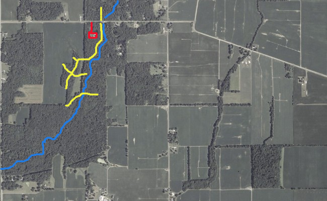
Ok, the blue is the creek, the yellow are the Majordeer trails, and the red is the house and drive I park at....I have not even explored South of the trails, I've never bow hunted this place, shotgun hunted it twice, and each hunt was over in less than a hour

 09-19-2008 | 06:47 PM
#12
Nontypical Buck
Joined: Oct 2005
Posts: 3,249
Likes: 0
From: Iowa (Heartland USA)
Looking at the terrain, I'd suggest the following. All of them are using gentle slope access from the creek bottoms to the fields. Good luck brother.

09-19-2008 | 07:15 PM
#13
Thread Starter
Nontypical Buck
Joined: Oct 2006
Posts: 2,244
Likes: 0
From: Deer Country
ORIGINAL: AF Hunter
Looking at the terrain, I'd suggest the following. All of them are using gentle slope access from the creek bottoms to the fields. Good luck brother.
Looking at the terrain, I'd suggest the following. All of them are using gentle slope access from the creek bottoms to the fields. Good luck brother.
09-19-2008 | 07:42 PM
#15
Nontypical Buck
Joined: Feb 2007
Posts: 1,977
Likes: 0
From: Allegany County Maryland
Dennis check out my TOPO thread and Ron3775 gave some great tips on reading certain points on a topo!!
Glad you found it!!
You can just put me anywhere on that 200acres..!!! Haha
Glad you found it!!
You can just put me anywhere on that 200acres..
!!! Haha


