
|
Land Mapping Software?
I've been tasked by a buddy of mine to take our hunting experience into the 21st century. While there is definitely no substitute for "walking the land" we have toyed with the idea of making some modifications to his property. I know that items like Google Earth do a good job providing images, but I don't believe they allow for hypothetical modifications. Are there any good programs out there that can aid in the this task? I guess we'd love to be able to upload some hypothetical drawings to our GPS devices and say "this is where we'd like to put a quail field" or "if we cleared out this scrub oak it would make a great place for a chufa patch". Some brief searching online brought back the Terrain Navigator Pro product, but I thought I'd toss it out to the experts for opinions.
Thanks |
RE: Land Mapping Software?
TNP is a good, user-friendly program and you'll have access to good aerial photos.
|
RE: Land Mapping Software?
I use google earth and the paint program that's on all pc's, just save the pic and then open it in paint, fast, easyand FREE
|
RE: Land Mapping Software?
I think you can do what you are talking about in Google Earth. At least I think you can because I've been doing it.
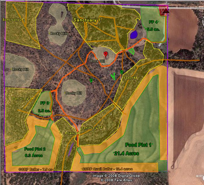 This is the free version, not the one you have to pay for. The benefit to doing it inside of Google Earth vs. doing it using a still image and the microsoft paint program is that you can zoom in on different areas and the shapes and markings zoom with you. I think you have to have the pay version to be able to calculate acreage with Google Earth but I use the USDA software to calculate the acreages and then just type those into Google Earth. |
RE: Land Mapping Software?
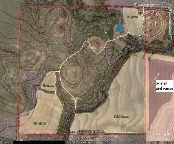
Here's an older version where I put an overlay of a topographical map over the Google Earth aerial image. This also zooms in and out in the same ratio. I pulled the topographical map from a free online service as well, I think it was topozone.com.
 Here's where I use the USDA soil survey information to calculate the acreages. It also gives you the soil types which is nice too. 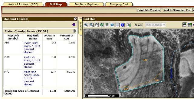 |
RE: Land Mapping Software?
ORIGINAL: npaden I think you can do what you are talking about in Google Earth. At least I think you can because I've been doing it. This is the free version, not the one you have to pay for. The benefit to doing it inside of Google Earth vs. doing it using a still image and the microsoft paint program is that you can zoom in on different areas and the shapes and markings zoom with you. I think you have to have the pay version to be able to calculate acreage with Google Earth but I use the USDA software to calculate the acreages and then just type those into Google Earth. |
RE: Land Mapping Software?
To transfer data to or from your GPS you have to upgrade to the "Pro" version which costs $20.
|
RE: Land Mapping Software?
ORIGINAL: npaden To transfer data to or from your GPS you have to upgrade to the "Pro" version which costs $20. |
RE: Land Mapping Software?
Here are a few pics from the TNP:
    |
RE: Land Mapping Software?
ORIGINAL: This is the free version, not the one you have to pay for. How do you do this? Can't figure it out. Had no idea this was available throught the free version. Thanks. |
| All times are GMT -8. The time now is 07:35 PM. |
Copyright © 2026 MH Sub I, LLC dba Internet Brands. All rights reserved. Use of this site indicates your consent to the Terms of Use.