


Topo map help
 05-31-2012, 06:35 AM
#1
Spike
Thread Starter
Join Date: May 2012
Posts: 2
Could you all look at this and help me read it and understand where I should hunt??
http://mapper.acme.com/?ll=37.87138,...%20Guston%20KY
A-L: Land I can hunt.
M: Soy bean/ corn field.
I can hunt some outside the lines that's just a rough estimate.
thank you.
http://mapper.acme.com/?ll=37.87138,...%20Guston%20KY
A-L: Land I can hunt.
M: Soy bean/ corn field.
I can hunt some outside the lines that's just a rough estimate.
thank you.
 05-31-2012, 07:38 AM
#2
Giant Nontypical
Join Date: Jan 2011
Location: Allegan, MI
Posts: 8,019
I'd find a couple pinch points from the heavy cover where they will be bedding and find trails going to the closest edges of the corn and soybean fields to set up my stands. Then when the season opens and you see the exact spots where deer are entering fields in the evening you may need to move the stands to within good shooting distance if where you're at is outside your comfortable shooting limits.
05-31-2012, 07:51 AM
#3
Fork Horn
Join Date: Sep 2010
Posts: 468
It also depends on how many other hunters are going to be on that land when your on it. If there is alot of pressure I had good success on woodlines and small patches of woods that divides fields and has access to large wooded areas
05-31-2012, 09:39 AM
#4
Spike
Thread Starter
Join Date: May 2012
Posts: 2
No pressure. I'm the only one allowed on it.
05-31-2012, 02:33 PM
#5
Nontypical Buck
Join Date: Jan 2008
Location:
Posts: 2,186
Without me putting boots on the ground, hard to tell. From the map, I'd "guestimate" the larger wooded area to the south/southwest would be a good place to hone in on. If there are a good many acorn bearing oaks in that patch of woods, I'd be darned sure to check these out come fall for deer sign. Right now, if I were scouting, I'd be looking for old rubs and creek crossings. You got trail cameras? If so, set one up over a "corn pile" or overlooking a creek crossing and see what shows up.
06-02-2012, 09:37 AM
#7
Spike
Join Date: May 2012
Location: northeast TN
Posts: 18
I would personally start out at somewhere between points B and C, preferably with a view of the pond.. Theres plenty of wood cover, plenty of field, and you might be able to catch deer coming into get a drink at the pond.
06-02-2012, 01:11 PM
#8
Spike
Join Date: Jun 2012
Location: Addison Michigan
Posts: 11
I would definitely agree you should find where the bedding and feeding areas are and set up on travel routes in between. There are some classic looking travel routes in your map, but without knowing if there is any reason for them to take it you can't be sure from looking at an aerial. Boots on the ground is what is needed as someone else said.
Here are some examples (white lines) on your map of what may be some travel corridors. But there has to be some reason for them to travel along those routes in day time to make them good hunting spots, so that requires understanding the locations of bedding and feeding areas and how they travel to and from them.
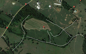
Here are some examples (white lines) on your map of what may be some travel corridors. But there has to be some reason for them to travel along those routes in day time to make them good hunting spots, so that requires understanding the locations of bedding and feeding areas and how they travel to and from them.
06-04-2012, 05:02 AM
#9
Giant Nontypical
Join Date: Jan 2011
Location: Allegan, MI
Posts: 8,019
Good post Jim, from one Michigander to another! The only problem with the post about the pond is that we don't know how far north this place is and if the hunting season he hunts is late enough in the year the pond may be frozen. It may be a great setup for early bow season though.
Last edited by Topgun 3006; 06-04-2012 at 05:05 AM.