
|
Creating a map of my ranch
Folks,
I am currently mapping out my farm/ranch with a GPS to make a record of where all my tree stands are, main deer traffic corridors, past rubs and scrapes, bedding areas, etc. This is OK to view on the GPS and I can open all of these waypoints into Google Earth. However, what I really want is to be able to create a printed map with satellite/aerial background and showing all the boundaries along with all my locations showing. I mainly want this for my dad as he isn't much on using any GPS. Does anybody know how to do this or know of a company that specializes in creating these types of things? My tree stands are permanent and the traffic corridors and food and water areas stay the same so having a printed map of all this stuff seems like a good idea to me. Just curious. If you are interested in the same thing, please post a note also so I can be sure to update the group if I find this out on my own. |
I usually use Photoshop, import the aerial, the tax map and then find some of the GPS points from items that are clearly visible in the photos. Forutunately, I have a large printer/plotter to print on. There are alot of photo-editing software packages out there that you could use. You'll need hi-resolution images so that when it is printed on poster size it will still look OK without the pixelation.
|
Usaphotomaps is a awesome program. You can plug your GPS into your PC and upload/download waypoints/routes etc right on Satellite image of your property.
If you use a laptop it will plot your position realtime on satellite images. Its free. Link below http://jdmcox.com/ Regards Mike |
Originally Posted by NCHunter70
(Post 3589231)
I usually use Photoshop, import the aerial, the tax map and then find some of the GPS points from items that are clearly visible in the photos. Forutunately, I have a large printer/plotter to print on. There are alot of photo-editing software packages out there that you could use. You'll need hi-resolution images so that when it is printed on poster size it will still look OK without the pixelation.
|
I made maps of the hunt club using my gps and a website called gpsvisualizer.com. I'm not sure if it's what you are looking for but here is an example:
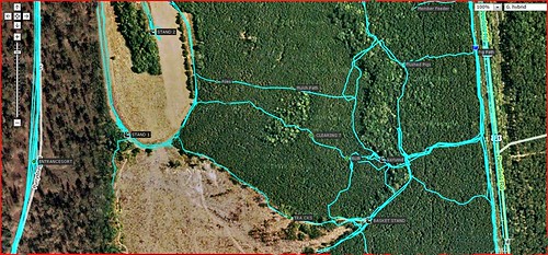 I use the snipping tool to take screen shots of the maps when I am at that website. You can zoom in and out, depending on what detail you need. I don't know if you can tell but the pic has waypoints marked with lables by them. |
I used ArcGIS until the company downsized and I became unemployed. A GIS program will create amazing maps, and creating a GIS allows much more information than a map. But using a professional program comes at a very hefty price, and quite a bit of time to learn how to use them to their full potential.
|
| All times are GMT -8. The time now is 02:53 PM. |
Copyright © 2024 MH Sub I, LLC dba Internet Brands. All rights reserved. Use of this site indicates your consent to the Terms of Use.