
|
TOPO Map Readers....see anything???
Do these things come with instructions or what??? Haha..this is a small area I have hunted for years and decided to pull up a topo map and see what it looked like...but in all honesty I aint got a clue what I am even looking at??? Someone wanna fill me in if anything sticks out to ya?? Iwill fill you in on what couple areas always seem to have the deer in them afterwards!! Thanks I am really curious what you guys see through reading these things????
   If the area is too small I understand and am curious about a much larger area as well if this is'nt readable!! |
RE: TOPO Map Readers....see anything???
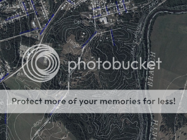
The lines increase/decrease elevation in 20 foot increments, you just have to follow the lines.Hunt right on top of that 700, or just south of it facing north. Looks like there are 3 good hollows, maybe4,that feed into that creek bottom, that's your money spot.
|
RE: TOPO Map Readers....see anything???
Right along that bluff to the east would be good....That's a nice edge for them to follow. Also, the point dropping down into the creek bottom with the 700 elevation just to the west of that bluff would probably also be good.
To learn how to read topos, do yourself a favor and invest in the book, "Mapping Trophy Bucks" by Brad Herndon. |
RE: TOPO Map Readers....see anything???
I take it you were able to find that mapping tool Seth:)
Here are some of the places I may look. As already stated the Bluff along the river to the East is a good starting point. This ridge that is perpendicular to the bluff looks like a great spot to key in on as any deer moving north south will have to either cross the ridge in that little saddle or go around. Any deer that cross at the saddle are likely to be funneled up the two draws or creek beds that are also marked as that will probably give them the best cover while they're moving.  |
RE: TOPO Map Readers....see anything???
see if this helps
 |
RE: TOPO Map Readers....see anything???
Thanks Ron~~ I am looking over it right now!
|
RE: TOPO Map Readers....see anything???
Well,
In looking at it go to the "S" on the word Lakes. Go north east from there on the areial photo and you will find a white outline with a bunch of little dots in it. if you take that and zoom in real close you will see Big Foot! I would not hunt those woods:D ....that said...lines that are very close means it is steep. lines that make a "V" mean a canyon and if you go up the "V" you are going up the mountain and that usually means there is a stream bed in the "V." |
RE: TOPO Map Readers....see anything???
nice post ron
|
RE: TOPO Map Readers....see anything???
I have to agree with SS56. That stop near the 700 contour is where I would be.
|
RE: TOPO Map Readers....see anything???
I would look here, for various reasons.
 |
| All times are GMT -8. The time now is 07:51 PM. |
Copyright © 2026 MH Sub I, LLC dba Internet Brands. All rights reserved. Use of this site indicates your consent to the Terms of Use.