
|
Aerial Maps
I've been reading alot of articles on scouting here recently and alot of people are talking about using aerial maps for their scouting. I just wanted to see what all some of you would try to gather from a couple aerial pictures of some of the land I hunt.
What exactly would you be looking for? What do you actually see in these pictures? Where would you position yourself? I basically want to pick your brain and see how you read this....What ya got for me? 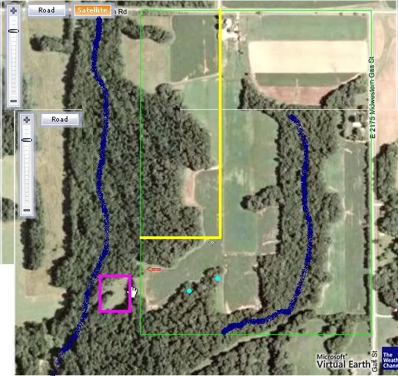 *The fields are beans and in winter wheat right now. Green Box= Property Yellow Line= The small segment blocked off by the yellow is already hunted by a couple of guys Pink Box= Food Plot Blue Streak= Creeks Red Arrow= Biggest rub(s) I've ever seen in my life!! Turquoise Dots= Stands I have up now  |
RE: Aerial Maps
Well, if North is the top of the map and south is the bottom, so on and so on. I'm going to say that inside corner south east of your current stands right next to that creek should be hot. It should serve as somewhat of a funnel as well.I know it's tempting to hunt those field edges but if you back of a little bit you will catch more deer before dark. Where you got marked for those huge rubs is a perfect staging area for a buck. My guess is he is bedding close to that creek and then makes he's way towards that field before dark and then "stages up" in that little point until it is completely dark.
|
RE: Aerial Maps
ORIGINAL: 2 Lunger Well, if North is the top of the map and south is the bottom, so on and so on. I'm going to say that inside corner south east of your current stands right next to that creek should be hot. It should serve as somewhat of a funnel as well.I know it's tempting to hunt those field edges but if you back of a little bit you will catch more deer before dark. Where you got marked for those huge rubs is a perfect staging area for a buck. My guess is he is bedding close to that creek and then makes he's way towards that field before dark and then "stages up" in that little point until it is completely dark. |
RE: Aerial Maps
These are the spots I would at least check out.They also depend on direction of prevailing winds.The other hunters should force deer towards #1 and #2.#3 looks like a funnel between creek and field.#4 is close to food plot and away from pressure.
 |
| All times are GMT -8. The time now is 01:54 AM. |
Copyright © 2026 MH Sub I, LLC dba Internet Brands. All rights reserved. Use of this site indicates your consent to the Terms of Use.