


New Property Aerial Pic and Topo - 675 Acres
 04-09-2008, 08:08 AM
#1
Nontypical Buck
Thread Starter
Join Date: May 2004
Location: Albany, NY
Posts: 4,679
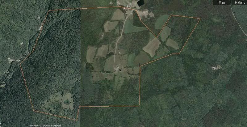
Just wanted to see what you guys thought of these. Dan and I will hopefully be headed out there next weekend to help the landowner with some work around the farm, and to hopefully put in some shoe leather as well.
Anything stand out immediately to you guys that we should head to first that weekend to check out more? We obviously aren't going to cover this whole thing in one day, so I'm curious to see what you guys think are blatantly obvious spots, and we can focus on these spots on our first scouting trip. I have no idea what crops may/may not be on here right now, but hopefully we will figure that out soon. There is also another 100+ acres to the north of this that I didn't cut into the map, we will have to check that part out ourselves I guess.
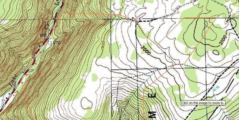
I had to cut the bottom off the topo so that I didn't put up too much location specific info....... . It's so steep there anyhow I don't think there is much that is huntable. It is south facing though so I'll get some time in there to see if they are using it for bedding, but I'm not sure if I'll actually hunt it there or not.......we will see. Most all entry to stand locations is going to have to come from the North, I don't see us hiking up 500-800 feet of elevation w/ stands and packs to get in there from the west or the south unless someone sees a very compelling reason to do so.
Anything stand out immediately to you guys that we should head to first that weekend to check out more? We obviously aren't going to cover this whole thing in one day, so I'm curious to see what you guys think are blatantly obvious spots, and we can focus on these spots on our first scouting trip. I have no idea what crops may/may not be on here right now, but hopefully we will figure that out soon. There is also another 100+ acres to the north of this that I didn't cut into the map, we will have to check that part out ourselves I guess.
I had to cut the bottom off the topo so that I didn't put up too much location specific info.......
. It's so steep there anyhow I don't think there is much that is huntable. It is south facing though so I'll get some time in there to see if they are using it for bedding, but I'm not sure if I'll actually hunt it there or not.......we will see. Most all entry to stand locations is going to have to come from the North, I don't see us hiking up 500-800 feet of elevation w/ stands and packs to get in there from the west or the south unless someone sees a very compelling reason to do so. 04-09-2008, 08:49 AM
#3
Giant Nontypical
Join Date: Feb 2003
Location: North Lima Ohio & Clarion Pa
Posts: 6,453
Nice looking piece of Property you should be stoked! It must be right on a line of updated vs old aerial photos.
You got lots of walking to do. That will be fun! Take 2way radios so you guys can cover ground and share insights.
Knowing your entry is north..of course the south is where you find the best areas..
You got lots of walking to do. That will be fun! Take 2way radios so you guys can cover ground and share insights.
Knowing your entry is north..of course the south is where you find the best areas..
04-09-2008, 09:31 AM
#4
Nontypical Buck
Join Date: Jan 2008
Location: Southern Illinois
Posts: 1,559
Holy cow that would be fun to hunt. I would be checking out the secluded fields in the SW. After that, you have many hours of checking all the different travel routes to the fields. You might have wear a pair of boots out checking this place over. Nice problem to have!
04-09-2008, 11:36 AM
#5
Nontypical Buck
Join Date: Jul 2006
Location: Wright, WY
Posts: 1,281
I like the field that is almost dead center in the picture. It is the one closest to the densest cover and ridges. It looks like a good property. I imagine you will find deer all over the place. That is where I would start hunting if I had to pick.
04-09-2008, 12:48 PM
#6
Nontypical Buck
Join Date: Apr 2008
Location: Pingree Grove, IL
Posts: 1,204
ORIGINAL: kickin_buck
Holy cow that would be fun to hunt. I would be checking out the secluded fields in the SW. After that, you have many hours of checking all the different travel routes to the fields. You might have wear a pair of boots out checking this place over. Nice problem to have!
Holy cow that would be fun to hunt. I would be checking out the secluded fields in the SW. After that, you have many hours of checking all the different travel routes to the fields. You might have wear a pair of boots out checking this place over. Nice problem to have!
04-09-2008, 01:28 PM
#8
Nontypical Buck
Join Date: Feb 2007
Location: Nashville, Ohio
Posts: 1,109
Looking at the topo of theh property there is going to be a ravine or steep creek bankwhere thecreek runs through the northwest corner of the farm. The deer will use very specific spots to cross the ravine/creek bank. Look for "S" turns in the creek often times the backs will be lower in the middle of the "S" funneling the deer to cross there when not pressured. I would also check the bech between the 1500' and the 1600' elevation lines that appears to be the place at which the timber thins a little. Ihave found that bucks like to tavel these transition lines and the bench makes a good travel corridor and there is probably some type of mast there as well.
04-09-2008, 06:05 PM
#10
Nontypical Buck
Join Date: Jul 2006
Location: St. Louis, MO
Posts: 4,487
Matt, you put a stand where that red dot is, and hunt it during the rut, and I guarantee you will see bucks.That has to be a major cruising intersection.

That has to be a major cruising intersection.