


*Aerial + Topo* - Stand placement ideas - help me hunt this patch
 09-18-2007 | 12:20 PM
#1
Thread Starter
Nontypical Buck
Joined: May 2004
Posts: 4,679
Likes: 0
From: Albany, NY
Let me start with a picture and explaining what everything is:
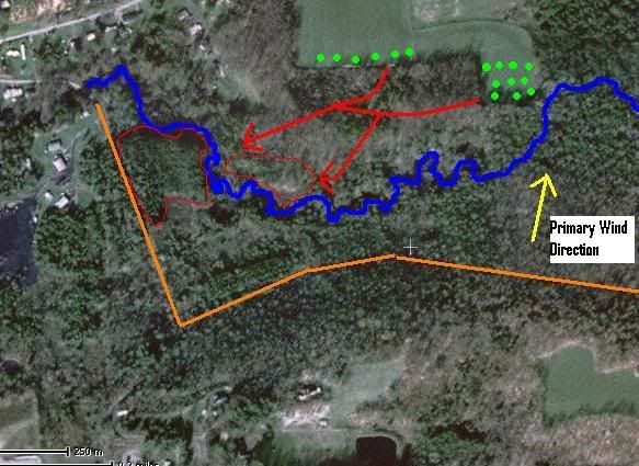
The green dots represent where these deer are feeding at night and just before first light. The blue represents the creek that runs through the property. The red arrows represent the path taken from the alfalfa field to their bedding areas. The red circled areas represent where they like to head to after first light to bed for the day. The yellow arrow represents primary wind direction. Finally the orange lines represent roads that I can break off of for entrance and exit to and from stands.
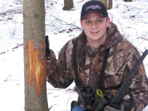
I currently havea lock on stand located just where the two seperate bedding areas come together, just on the west side of that creek. There is always TONS of deer movement in here, you are pretty much guaranteed to see deer between 8:30am and 10:00 am when they finally make it this far, however I end up getting winded every time due to stand location. I have only hunted this in the morning, because by evening there is no way to get in here without blowing the deer out unless I enter from the north. This area traditionally gets trashed with huge rubs (the pic below is taken right where the crossing between the two bedding areas come together) but I never see bucks in here. I assume they are smelling me and I never see them.
How would you hunt this? I'm most interested in hearing how you would hunt the north side of that creek. I can enter from the south, west, or from the fields on the north of this though. What time of day, and what entrance/exit routes would you use?
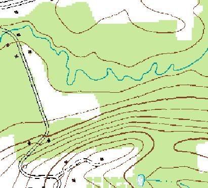
I know there is a resident slammer in here, I've seen his rubbed trees 3 years in a row now all rubbed over and over again, I just don't think I am hunting this section right. I'm assuming the way to hunt this is to only hunt in the evenings using an entrance route from the north, and exit trail to the south. There is a terrain feature edge that drops off on the north side of the creek directly into the creek with heavy cover and thick hemlocks running the edge of the creek, and while this looks like ideal cover for that movement from the food to the bedding there is rarely good sign in there in terms of rubs, etc. Should I hunt this edge on the north side of it for wind direction and hope this funnels them along the creek upwind of me?
Your thoughts?
The green dots represent where these deer are feeding at night and just before first light. The blue represents the creek that runs through the property. The red arrows represent the path taken from the alfalfa field to their bedding areas. The red circled areas represent where they like to head to after first light to bed for the day. The yellow arrow represents primary wind direction. Finally the orange lines represent roads that I can break off of for entrance and exit to and from stands.
I currently havea lock on stand located just where the two seperate bedding areas come together, just on the west side of that creek. There is always TONS of deer movement in here, you are pretty much guaranteed to see deer between 8:30am and 10:00 am when they finally make it this far, however I end up getting winded every time due to stand location. I have only hunted this in the morning, because by evening there is no way to get in here without blowing the deer out unless I enter from the north. This area traditionally gets trashed with huge rubs (the pic below is taken right where the crossing between the two bedding areas come together) but I never see bucks in here. I assume they are smelling me and I never see them.
How would you hunt this? I'm most interested in hearing how you would hunt the north side of that creek. I can enter from the south, west, or from the fields on the north of this though. What time of day, and what entrance/exit routes would you use?
I know there is a resident slammer in here, I've seen his rubbed trees 3 years in a row now all rubbed over and over again, I just don't think I am hunting this section right. I'm assuming the way to hunt this is to only hunt in the evenings using an entrance route from the north, and exit trail to the south. There is a terrain feature edge that drops off on the north side of the creek directly into the creek with heavy cover and thick hemlocks running the edge of the creek, and while this looks like ideal cover for that movement from the food to the bedding there is rarely good sign in there in terms of rubs, etc. Should I hunt this edge on the north side of it for wind direction and hope this funnels them along the creek upwind of me?
Your thoughts?

 09-18-2007 | 12:55 PM
#5
Thread Starter
Nontypical Buck
Joined: May 2004
Posts: 4,679
Likes: 0
From: Albany, NY
ORIGINAL: JoeRE
Other than between the bedding areas, are there othercertain deer crossings along that creek...for instance farther east?
Other than between the bedding areas, are there othercertain deer crossings along that creek...for instance farther east?

Thread
Thread Starter
Forum
Replies
Last Post
Rick James
Bowhunting
19
06-04-2007 12:01 PM
Rick James
Bowhunting
12
05-22-2007 08:14 PM
