
|
RE: Photo and topo gurus........lets hear your thoughts
ORIGINAL: davidmil And man, if you have access to the land to the south you got a slight saddle with a creek below on the East Southeast side and the gradual finger in the big woods just across the property line that leads to the same drainage. Got to be deer coming through there. 
|
RE: Photo and topo gurus........lets hear your thoughts
ORIGINAL: davidmil Huntingson... how can you say the topo is of little use and shows not much elevation changes. You being from flat Ohio and all. There is in fact an elevation change of 260 feet plus on this map. I'd call that some pretty good terrain changes. However, I would argue with you that Ohio is flat. Have you been to eastern and/or SE Ohio? Very hilly. Makes that property look flat. Plus, only the SE corner of the property has any significant elevation change. Significant being in MY hunting sense.The layout of the vegetation would have much more impact here (I think) than the elevation changes. |
RE: Photo and topo gurus........lets hear your thoughts
That is unfortunately a spot I can't hunt. I can't hunt the east, southeast, or north. I can use the North to access my patch though. I canwatch that saddle though from my Taj Mahal stand and see deer every time in it however no big bucks. They leave the neighbors plots and go through that spot on the way to my sidehill to bed every morning. I catch them at the stand just north of my foodplot after they go through that saddle. Huntingson, even in the flatter parts of this property, with a topoyou can see the streams and drainages that deer will travel through. Topos show greenery and vegetation, although not what type. The only problem with that is some topos(most I guess) are dated. Even so, and area that used to be an opening in big timber will be white. If the topo is old those areas may very well have grown over a bit, but it'll be brushy browse stuff where deer will still like to travel forsecurity reasons. YUP, I know all about Eastern Ohio, but I also have hunted the flat lands of which most of Ohio is famous for.[8D] |
RE: Photo and topo gurus........lets hear your thoughts
Good point David, the fact that the topo showed vegetation had actually slipped my mind. I mainly use them to find saddles in ridges and flats on ridge tops. small drainages and minor depressions, at least where I hunt don't seem to cause major travel routes unless they are steep, but I certainly have not hunted everywhere. Other than the major things like mentioned above I rely mostly on my feet. I scout mostly by covering a lot, LOT,of ground. That IMO is the only true way to scout. The topos and maps just give you a place to start. Again, just my opinion.
|
RE: Photo and topo gurus........lets hear your thoughts
Me too. It doesn't mean a thing until you walk it. The topos can give you starting points and if you're on a short time frame maybe weed out some unproductive time consuming stuff.
|
RE: Photo and topo gurus........lets hear your thoughts
So I thought I would bump this up a bit. I got some really good info that I valued from members here the last time......
The neighbor to the west of us gave me exclusive permission for this year. I don't know the exact amount of property there, but I believe it is around 75 acres. I have walked the south side of the property line at this point, as well as that field you see on top of the knob in the southwest corner. I killed a turkeyin that field on the knoblast spring the first time I walked on the property and found quite a few rubs on the trees on the east edge of that field on the knob......also there is a heck of a funneled crossing on the main hollow that runs off his southeast corner of the property near my property line. My place is the orange line, his is the pink line. How would you hunt his side and why? We primarily have a southwest wind here........ General view of the Bradford County valley showing both of our properties and the surrounding agriculture.  Property zoomed in a bit comparable in size to the topo below it.....  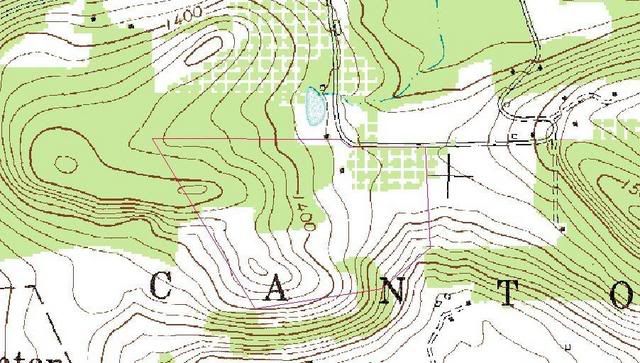 |
RE: Photo and topo gurus........lets hear your thoughts
Just by looking at the maps I would hunt here. Look like a key spot, probably a scrape line there every year.
 |
RE: Photo and topo gurus........lets hear your thoughts
Just bumping this back up. There are several people here who's input I really value quite a bit with some great experience picking up on things on a topo map. Specifically I am looking for input on the area with the pink outline........
|
| All times are GMT -8. The time now is 01:20 AM. |
Copyright © 2026 MH Sub I, LLC dba Internet Brands. All rights reserved. Use of this site indicates your consent to the Terms of Use.